Mount Fuji hiking season ends in the early September. They say it can be dangerous after that, mostly because of changing weather, snow, avalanches and so on. They say you shouldn’t climb Fuji-san in late September or later.
I sometimes like to think of myself as a person who doesn’t need to be told the same thing twice. So at 5 am on Friday morning I was already on my way to Fujisan.
It’s a bit of a journey from Tokyo. First I had to get to the train station. Then take a train to another station on the outskirts of Tokyo (Takao station). Then another one to Otsuki. Then one more to Fujisan station. And then the bus to the 5th Station by the Mountain.

Overall it took me over 5 hours from getting out of my hostel to arriving at the 5th Station.
The 5th Station is a place where hiking trail to the Mount Fuji starts. The station is at an altitude of 2400m. From that place you’ve got around 7km long hike. With about 1400 m climb, that gets you to the rim of the crater of Mount Fuji.
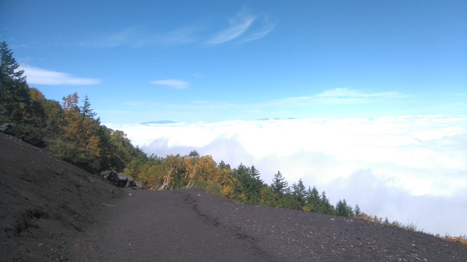
The good thing is that clouds on that day ended at about 1500 m, so it was already sunny at the 5th station. I checked what time the last bus down to the train station was (17:50), and set off. It was just before 11 am.

Some online resources say it’s about 5-6 hours to climb Fuji-san from 5th station, and about 3-4 hours to get back. That would mean I’d struggle to make it back for the last bus, but I already knew that those times are usually with a good margin. The weather was great, no trace of snow - it shouldn’t take nearly as long.
The first obstacle arose just after 10 minutes of walking. A sign saying that the trail is closed. But there was no sign saying it’s forbidden to use it, it just said that the local authorities won’t be held responsible for any injuries or fatalities when the trail is closed. Fair enough. From my online research (I mean, a website I read. But it’s cooler to call it “research”, isn’t it?) I knew that people basically ignore this sign and carry on. So did I.
The trail is pretty steep. If you do the math and divide the altitude gain by the total distance, you will know that it really is. Since the trail starts at a fairly high altitude, the forest ends quickly and you walk on uncovered, steep, volcanic ash covered slope. Surprisingly, there are plenty of construction workers around, building new paths and constructions to block avalanches and to prevent debris from falling (and killing people - there are casualties every year due to falling debris and avalanches). Apparently, avalanches are quite common when it gets snowy. It makes sense, as the slopes are just soft volcanic ash and stones, with almost no vegetation.
But seeing all those workers and heavy machines they use makes you think that it’s probably not nearly as dangerous as they try to convince you. I guess it gets dangerous when snow falls, but not on a sunny, warm autumn day.
But there are good things that one owes to all those scaremongers - there are almost no other people on the trail. During my hike, I met less than 20 other tourists, and around 10 workers (although they were present only in the lower parts of the mountain). In the summer there can be up to 10000 (!) people on the mountain in one day! I guess it kills the experience a bit.
Back to hiking. It’s not very long, but it’s steep, and therefore hard. And it’s on altitude. The summit is at 3776 m above the sea level. Covering that much in one day (starting from Tokyo at near zero altitude) is a lot and you can feel it more and more, the closer to the top you get.

A piece of advice: practice your all fours walking skills before, as the wind gets so strong on the crater that there is a risk of being blown away into it. Not that there is any hot magma, burning inferno, angry crocodiles or Millwall FC fans in it, but still something to avoid. Good all-fours crawling workshops can be booked at we_drink_till_we_cant_walk_anymore@gmail.com.

Finally, I got to the summit, took a mandatory selfie with a sign (I hope it was saying that it’s what I thought it was. Could’ve been tofu ramen recipe as far as my language skills are concerned, but Japanese are clever and practical people. Why would they made people take pictures with a ramen recipe carved in the stone? Or - if they wanted - what would be the point of getting them all that high, while you can make perfectly fine pictures at the train station, or at the airport).
Since it was still early and I was expecting descent to be much quicker than the ascent, I thought I may be able to catch an earlier bus. I walked back around the crater to the Shinto temple on the other side (yes, that’s true. There is a temple. At 3700+ altitude. It didn’t grow there, someone had to carry all that stuff there and actually build it). I guess it’s an important one as well, as Mt Fuji is one of the three holy mountains in Japan (along with Mount Tate - Tateyama, and Mount Haku - Hakusan).
The first part of the descent is a kind of stone stairs, so you can’t go much faster. But then - next to the main trail - starts a series of wide paths prepared by bulldozers. Since the surface is covered with thick ash and small stones, it’s easy to go down really fast. Actually, I figured out that if you lean backwards, you can start running/jumping down. Add a bit of twisting and you have something that resembles downhill skiing. With the difference that instead of nice, white snowy dust, you’re leaving dark grey volcanic ash dust cloud behind you. But it’s not diminishing the fun in the slightest.
So I started doing that remembering to apologise to my quads later (quads have to work hard, as you need to be braking almost constantly). And I guess I got a bit carried away. After some time (probably not very long, as you can go pretty fast this way) I noticed that the trail that used to be on my left side is not there anymore. It got lost and replaced by a forest. Since I had no idea how to call a trail in Japanese, not to mention how to ask it to come back, I decided to look at the map.

I put my destination in, and it said I’ve got 2 hours and 8 minutes to the 5th station, where my bus was leaving from. And that meant going back uphill for quite a while, and then turning right, and going down for another while.
It was 16:04, which meant I didn’t have 2:08, but less than 1:46 to get there (the last bus leaves at 17:50).
Panic starts. Suddenly my ramen dinner I was picturing for the last couple of hours started disappearing and turning into tree bark, roots, and small, injured-or-terminally-ill animals dinner. Nah, that doesn’t sound good.
But if map says to go up and right, what if I go right straight away, without going up? That seems like a better plan.
If only local road builders had known my plan before, I’m sure they’d made it easier for me. Unfortunately, their technology is not that advanced yet, so I had to make my way through the forest. Luckily I found a path quite soon, that - as it turned out later - was designed for idiots like me (later on the bus I learned that at least 5 other guys did pretty much the same thing that day).
Part walking, part running, constantly blessing Japanese path builders for marking it clearly, I made my way to the station. With enough time to take some photos of the sun setting behind the mountain into the sea of white clouds.

About 4 hours later I’m back in Tokyo. Ramen was delicious.
More pictures here.
No comments:
Post a Comment